About Puerto Villa Constitucion
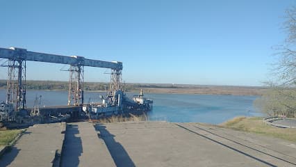
Port of Villa Constitucion This commercial port for public use is located on the right bank of the Main Navigation Channel of the Paraná River. It starts at km. 365 of the Paraná River, in the section of the waterway suitable for the entry of overseas ships, developed on an arm of the water course and protected by an artificial dam. Communication between Villa Constitución and the Atlantic Ocean occurs through the navigation route made up of these sections: Paraná Inferior, Paraná de las Palma, Río de la Plata. Between Km. 360 and 365 of the Paraná River, on the left bank there is the area called "Rada and Maneuvering Zone", with an anchoring capacity for 5 overseas ships, without length limits, not presenting depth problems and allowing the possibility of an extension of the same, according to the topographical conditions of the place. Currently, this port is managed by the Administrative Entity of the Port of Villa Constitución and has two well-differentiated zones: the northern zone, also called overseas, and the southern or cabotage zone. In addition, it is also made up of a terminal elevator (Unit I) with an operable site, the Port Services dock (Unit II) with two docking fronts, the cabotage dock and the Acindar docks in Puerto Acevedo. Its main activities are oriented to shipments of grains and oilseeds, concentrating most of them in the dock of Unit II (elevator of Port Services) concessioned to the same company that operates the loading facilities of Unit I. Located 55 kilometres south of Rosario and 230 kilometres from Buenos, it becomes a strategic space for international trade and export development, since it is located in the centre of the Paraná - Paraguay Waterway, and in the heart of the industrial axis La Silver - Rosary. The components subject to tender are the export processing zone, the commercial-free zone (with a port terminal) and the services and administrative support area.
Facilities
Port Information
Telephone
Berth Sizes
Manoeuvrability
Channel Marking
Port of Entry
Tidal Flow
Active Winter
Weather Forecast
 S 4–8 knots.
 10°C
10°C UV Index: 0 - Low
 Cloudy
- S 6–9 knots.
- 10 to 12°C
- UV Index: 1 - Low
- Cloudy
- SE 8 knots decreasing to 6 knots.
- 12°C
- UV Index: 0 - Low
- Cloudy