About Luka Brgulje
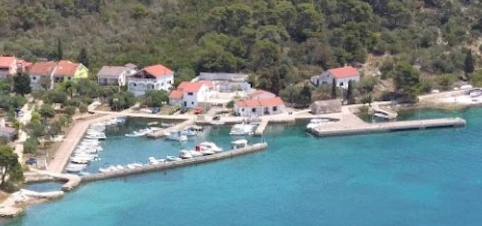
Brgulje lies around two miles NW of Molat Town and half a mile inland from a tiny harbour and mooring buoy field sheltered from W by the small island of Bruglje Otok. The harbour is too shallow for yachts, but the municipality has laid 17 mooring lines on the outside of the N breakwater for visiting yachts. Depths here are barely 2.0 metres, so it is best to go bows-to if using these. There is water and electricity on the breakwater, and toilets and showers are available. Alternatively, pick up one of the 92 mooring buoys that have been installed between the harbour and the island of Brgulje Otok in depths of 4.0 - 6.0 metres. There are no facilities on the buoys, although refuse is collected. Charges on the mooring lines (November 2012) are Euros 2.2 per metre including water, electricity, toilets and showers and on the buoys Euros 1.91 per metre including refuse collection. Shelter here is good in all but S winds. The port of Brgulje covers 15,496 m2, of which the land area is 2,194 m2, and the sea area is 13,302 m2. The port of Brgulje has an operational part of the port which consists of an operational pier with a plateau 48 m long. The port of Brgulje has a nautical part of the port located on the outside of the pier, 63 m long. The rest of the port of Brgulje is intended for communal communication.


Servizi
Port Information
Telefono
Berth Sizes
Profondità alla Bassa Marea Media
Manovrabilità
Channel Marking
Porto di Entrata
Overseas Visitor Berths
Tipo di Molo
Style Stern To
Tidal Flow
Weather Forecast
 NW 1–7 knots veering E 1-7 knots.
 27°C
27°C Calm sea
 UV Index: 2 - Low
 Sunny
Sunny
- E 4 knots increasing to NW 8 knots.
- 26°C
- Calm sea
- UV Index: 8 - Very High
- Sunny
- W 8–10 knots.
- 27°C
- Calm sea
- UV Index: 8 - Very High
- Sunny