About Onslow Maritime Facility
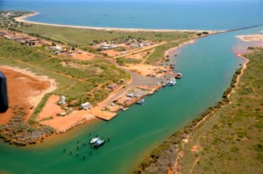
Onslow is a coastal town 1,386 kilometres north of Perth, in the Pilbara Region. It is known for excellent fishing. The maritime facility is approximately 550 metres south of the entrance to Beadon Creek. The main users of the facility at Onslow include the resources sector, fishing and charter vessels. Fishing operations are carried out all year round. With the extensive growth of oil and gas projects in the region, the facility has become a supply base for offshore operations. The facility comprises of ten berths on mooring piles, a service jetty, dual public boat ramp, vessel diesel fuelling facilities, as well as a fish cleaning table and public car park. Ongoing development will increase the commercial facilities available at the site. Boating facility fees Fees are payable for the use of maritime facilities throughout the state. Please refer to the schedule of maritime facilities fees and charges. http://www.transport.wa.gov.au/imarine/facilities-and-waterwayfees.asp All customers should contact the Department of Transport’s (DoT) Onslow Harbour Coordinator on 0467 811 543 prior to arrival to ensure suitable facilities are available and to receive all relevant documentation and facilitate payment. It is a condition of use that all users comply with DoT’s gas, electrical, insurance requirements and terms and conditions. These documents can be found at http://www.transport.wa.gov.au/imarine/general-userequirements.asp Waterway Entrance channel The entrance to the Onslow Beadon Creek Maritime Facility requires regular dredging. Please refer to the current Cyclone contingency plan: Onslow (Beadon Creek), which can be found on the Transport website, for further details of the dredged depths. Latitude: -21.646 S Longitude: 115.131 E Boating facilities Mooring piles There are 21 mooring piles forming eight vessel pens toward the south of the facility in Beadon Creek. The mooring piles are in an area known locally as "The Sticks". Two additional sites outside of the sticks can also be utilised for berthage in approved circumstances. In the western creek arm a further six piles form two vessel pens for larger barges during the cyclone season.
Servizi
Port Information
Telefono
Berth Sizes
Profondità alla Bassa Marea Media
Manovrabilità
Channel Marking
Canale VHF
Porto di Entrata
Overseas Visitor Berths
Tipo di Molo
Tidal Flow
Active Winter
Weather Forecast
 SE 6 knots.
 Increasing from 12 to 17°C
 NE 0.4m at 5s period
 UV Index: 0 - Low
 Sunny
Sunny
- SE 7 knots increasing to N 10 knots.
- Increasing from 20 to 27°C
- Calm sea
- UV Index: 6 - High
- Sunny
- N 9–12 knots.
- 23 to 27°C
- N 0.4m at 5s period
- UV Index: 6 - High
- Sunny